11 min read
“Aerial photography is a way of seeing the world that can change our perspective on it forever.”
—Ansel Adams
Since the birth of photography in the 19th century, ingenious pioneers have sought to elevate cameras higher and higher in pursuit of new photographic perspectives.
The history of aerial photography is a fascinating story of scientific creativity and perseverance in the face of technical challenges. This revolutionary technique has allowed humanity to see the world in ways never before imagined.
From the earliest balloon-mounted cameras to cutting-edge drone technologies, each new chapter in the development of aerial photography has profoundly expanded our visual understanding of the landscapes around us.
When the first grainy photographs were captured from the skies over Paris and Civil War battlefields, it was just the beginning of an extraordinary journey skyward.
Through two world wars, the Space Age, and the Digital Era, aerial photographers have tirelessly brought the world’s stunning vistas to all of us earthbound below.
Join us on an odyssey through the history of aerial photography, seen through the lens of the visionaries who took cameras boldly aloft into the great blue yonder.
In capturing the planet from above, they revealed Earth’s beauty in unforgettable images that shift our perspectives upward and outward.
THE FIRST AERIAL PHOTOGRAPH WAS TAKEN IN PARIS

The first aerial photograph represents a pivotal moment in the advancement of photography as an artform and technology.
In 1858, French photographer and balloonist Gaspard-Félix Tournachon, known by his pseudonym Nadar, pioneered the new technique of aerial photography.
An intrepid innovator, Nadar elevated his camera into the skies above Paris using a hot air balloon in order to capture a unique vantage point.
While preparing for his balloon flight, Nadar likely felt a mix of nerves and excitement, unsure of what photographic revelations awaited him above the clouds.
Once he was floating high above the urban metropolis in his balloon “Le Geant,” Nadar readied his bulky camera equipment and photographed the bustling city below him.
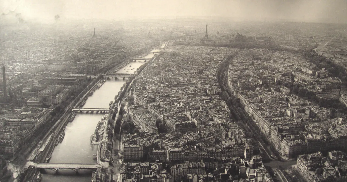
The resulting photograph, “View of Paris From a Hot Air Balloon,” offered the world a rare glimpse of a city from the air.
The small houses, winding alleys and streets of Paris spread out like a map below the balloon.
This was the brilliant beginning of aerial photography.
Nadar showed people scenes of the world they had never laid eyes on before.
His bold shot from above revolutionized photography as an artform.
In the years following Nadar’s pioneering aerial shot, photographers increasingly sought out aerial vantage points to showcase the beauty, expanse and details of the landscape in thrilling new ways, shaping the evolution of photography forever after.
AERIAL PHOTOS IN THE AMERICAN CIVIL WAR

During the tumultuous years of the American Civil War in the 1860s, aerial photography added a new dimension to military intelligence and reconnaissance.
As this new technology was emerging, both the Union and Confederate armies sought to gain an advantage by taking to the skies.
The use of aerial photography for reconnaissance represented a revolutionary development in wartime tactics. In order to gather crucial intelligence about troop movements, army engineers devised methods to hoist cameras into the air tethered to balloons.
Operators would ascend in the balloons high above battlefields and military installations, then photograph troop formations, encampments, and defensive fortifications from an unprecedented aerial vantage point.
Despite the bulky equipment and technical limitations of the time, these pioneering aerial photographers opened the door to a new form of reconnaissance.
The images they captured from above provided commanding officers with valuable intelligence that informed critical military decisions.
While primitive in comparison to modern aerial spy planes and satellites, these first aerial reconnaissance photos fundamentally transformed war tactics.
The Civil War marked the dawn of aerial photography’s essential role in military operations.
In an ironic twist, war ushered in some of the most rapid innovations in photography’s early history.
KITE AERIAL PHOTOGRAPHY

In the late 19th century, French inventor Arthur Batut creatively pioneered the new art of kite aerial photography.
While photographers had previously relied on hot air and gas balloons to photograph the world from above, Batut conceived an ingenious new method in the 1880s.
He attached his camera to a kite, using the wind-powered elevation to take to the skies with his equipment.
Through trial and error, Batut perfected his techniques for kite aerial photography.
He figured out how to rig the camera at just the right angle and how to keep the kite steady amidst gusts of wind.
By mastering these methods, Batut was able to capture breathtaking new perspectives of the French countryside from his camera floating hundreds of feet in the air.
Batut’s kite aerial photographs offered intriguing new vantages of familiar landscapes.
The bird’s eye views peered down at the winding country roads, farms, villages and rolling hills of rural France.
The images evoked a sense of weightlessness and freedom, as if the viewer herself was drifting in the sky overlooking the scenic vistas.
While balloons allowed higher altitude aerial shots, kite aerial photography provided photographers greater portability and control.
Batut’s ingenious use of the kite for aerial photos was a major milestone in the development of photography.
His creativity opened up the skies, letting cameras capture and share new perspectives of the world.
RECONNAISSANCE PHOTOS DURING WORLD WAR I

The onset of World War I in 1914 drove rapid innovation in aerial photography for military reconnaissance purposes.
As the war commenced, generals immediately recognized the immense strategic value of aerial photos for gathering intelligence.
Taking to the skies to spy on enemy positions and movements offered unprecedented advantages.
In response, tremendous efforts and resources were devoted to developing specialized aerial photography technology over the course of the Great War.
Dedicated reconnaissance airplanes were outfitted with powerful cameras using glass plate negatives that could capture detailed aerial shots.
Stereoscopic cameras were engineered to produce 3D images that could accurately identify enemy trench positions and terrain depth.
Large-format cameras were designed specifically to map landscapes for artillery.
Makeshift darkrooms were set up near airfields to quickly develop the photos taken on missions.
To increase the reach of reconnaissance, camera rigs were also fastened to observation balloons that lifted skyward from the trenches.
From these balloons, photographers had a more stable perch to meticulously photograph enemy lines through telephoto lenses.
The wealth of intelligence gathered from aerial reconnaissance photos became indispensable for planning offensives.
By the end of World War I, aerial photography had matured from its infancy into an essential technology for modern warfare.
The war’s demand for tactical advantages pushed rapid enhancements in aerial cameras, aircraft, and reconnaissance tactics that profoundly changed how militaries gather intelligence.
THE FIRST NIGHT AERIAL PHOTOGRAPHS

During World War I, British pilot Major Adrian Cole achieved a significant photographic first in 1917—the first aerial photos taken at night.
His ingenious technique provided invaluable intelligence by exposing enemy positions under the cover of darkness.
Taking crisp aerial shots from a vibrating biplane in pitch darkness presented a formidable challenge.
To capture illuminated images Cole improvised a clever system for night photography.
At great personal peril, he would manually hold large flash lamp bulbs out of the open cockpit during flight.
By triggering the flashes consecutively, Cole lit up the land below just long enough to expose photographic plates.
Cole’s daredevil maneuver required precision timing and steady hands.
With one hand on the camera shutter and the other gripping the flashing lamps out in the open air, he had to coordinate the illumination and photography while piloting the plane through black skies.
The technical limitations produced blurry, low quality photographs. But the mission was a success—Cole proved night aerial reconnaissance was possible.
The landmark nighttime aerial photos provided the British military new tactical advantages.
Cole’s ingenious technique laid the groundwork for major advancements in night photography and reconnaissance.
Thanks to his willingness to lean out of the cockpit with camera and flashes, Cole opened up the skies to military intelligence gathering 24 hours a day.
COLD WAR SPY BALLOONS

As Cold War tensions escalated in the late 1940s between the United States and Soviet Union, both superpowers scrambled to gain intelligence and strategic advantages over the other.
In 1947, the US embarked on a classified program to photograph Soviet territory from the edge of space using high-altitude balloons.
This covert operation was known as Project Mogul.
The project exemplified American innovation and ingenuity in the early Space Age.
To reach heights of up to 100,000 feet, the military worked with scientists to develop enormous balloons made of plastic.
Suspended below were customized camera payloads designed to withstand sub zero temperatures and minimal oxygen.
As the balloons ascended above Soviet airspace, the camera equipment silently photographed military sites and installations.
The first Project Mogul flight launched from New Mexico and floated eastward over the US, taking spy photos as a proof of concept.
Subsequent missions photographed Soviet nuclear facilities and missile test sites that were threats to US security.
The balloons could float unseen at jet stream altitudes, capturing unique intelligence.
Project Mogul demonstrated that space could be used for military reconnaissance and surveillance purposes.
Before spy planes and satellites, this top-secret balloon project pioneered high-altitude aerial photography.
AMERICAN U-2 SPY PLANES

The development of the U-2 spy plane by the United States in the 1950s marked a major milestone in aerial reconnaissance photography.
During the tense geopolitical standoff of the Cold War, the high-flying U-2 enabled the US to carry out covert intelligence gathering missions over enemy territories that were previously inaccessible.
Engineered by aerospace company Lockheed, the U-2 was uniquely designed for stealth and altitude.
Flying at up to 70,000 feet, it cruised above the range of anti-aircraft fire and early radar systems. Even higher than the ceilings of interceptor aircraft, the U-2 slipped across forbidden skies with impunity.
Equipped with powerful surveillance camera equipment, U-2 planes brought back photos providing invaluable insight about adversaries.
Missions over the Soviet Union, China, Vietnam, and Cuba photographed military bases, missile sites, industrial facilities, and troop movements.
The intelligence debunked claims and revealed secrets, shaping US strategy.
The U-2 spy plane ushered in a new era of aerial reconnaissance.
Never before had a nation possessed the capability to overfly and comprehensively photograph foreign territory in peacetime.
Though the U-2 flights were legally questionable, they demonstrated the potency of strategic high-altitude aerial surveillance.
AERIAL PHOTOGRAPHY HAS BEEN CONTROVERSIAL AT TIMES

Since its origins, aerial photography has provided mankind with astonishing new vantage points of the world.
However, the ability to capture images from the sky has also raised complex questions surrounding privacy.
Many have contended that photographs taken from aircraft without permission can constitute unethical invasions of privacy. This issue has sparked legal and ethical debates.
As aerial photography proliferated in the early 20th century, photographers reveling in their new bird’s-eye perspectives gave little thought to those observable below.
However, public attitudes shifted as aerial photography advanced from an exotic novelty to an everyday phenomenon.
Many bristled at the idea of pilots casually photographing private homes and property without consent.
Citizens and legal advocates argued for reasonable restrictions on aerial photography to protect privacy.
But legislation has struggled to balance privacy with aerial photographers’ free speech rights along with the public’s interest.
In United States law, photographs taken from airspace where pilots have a legal right to fly are usually permitted, regardless of subject matter on private land below.
Nonetheless, tensions around aerial photography linger. Navigating this issue requires nuance and ethical judgment.
While aerial photos provide many public benefits, photographers should consider the impact on private citizens’ rights.
The evolving discussion reflects deeper questions about advancing technology’s relationship to privacy in the modern world.